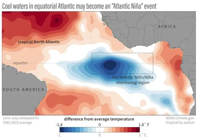
Scientists have been observing the Pacific Ocean change from El Niño’s warmer-than-average conditions a few months ago to cooler-than-average La Niña conditions by late summer or early fall. However, something similar may be taking shape in the Atlantic Ocean this summer.
The North Atlantic has been extremely warm so far this year, but as of the beginning of June, the Atlantic has been 0.5-1.0 degrees Celsius colder than average for this time of year. If these cold conditions persist through the end of August, a phenomenon known as Atlantic Niña may be declared.
Similar to ENSO patterns that swing back and forth between cold and warm phases every few years, the natural climate pattern known as the Atlantic zonal mode features cold and warm phases as well. The seasonal cycle of sea surface temperatures in the Atlantic are somewhat surprising, with the warmest waters of the year occurring in spring and the coldest waters occurring from July to August.
Atlantic Niña is the cold phase of the Atlantic zonal mode, while Atlantic Niño is the warm phase. Typically, 3-month averaged sea surface temperature anomalies in the eastern equatorial Atlantic have to exceed +/- 0.5C for at least two overlapping seasons to qualify as an Atlantic Niño or Niña.
Atlantic Niños can have a huge impact on rainfall over the surrounding continents, reducing rainfall over the Sahel region, increasing rainfall over the Gulf of Guinea, and seasonal shifts of the rainy season in northeastern South America. Atlantic Niños have also been shown to increase the likelihood of hurricanes developing near the Cape Verde islands. If Atlantic Niña does develop, the cooler water could have a dampening effect on hurricane activity as the season progresses. This could be an interesting development as numerous entities predicted an extremely active hurricane season.


