On Thursday, November 27, 2025, we collected forecast snowfall graphics from three of the major weather forecast providers in the United States: The Weather Channel, AccuWeather, and NOAA’s National Weather Service. Each of the forecasts were produced for the general timeframe of Friday through Sunday, November 28-November 30, 2025. With forecasts produced roughly 24-30 hours in advance, we thought it would be fun to see which provider(s) were more or less accurate for this storm system.
At ForecastWatch, we are the leader in business-critical weather and climate intelligence. Our suite of products provides our clients with weather forecast accuracy analytics to positively impact revenue, operating costs, and risk mitigation costs. We have collected over 2.5 billion weather forecasts in our proprietary database which we use to verify forecasts against actual observations. But today, we wanted to do a quick informal breakdown of the past weekend’s snow storm.
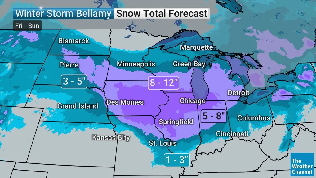
We briefly noted some of the differences between the forecasts. The Weather Channel predicted a swath of 8-12″ of snow across a large portion of Iowa into northern Illinois, with an area of 5-8″ of snow outside that area stretching from South Dakota to northwestern Ohio.
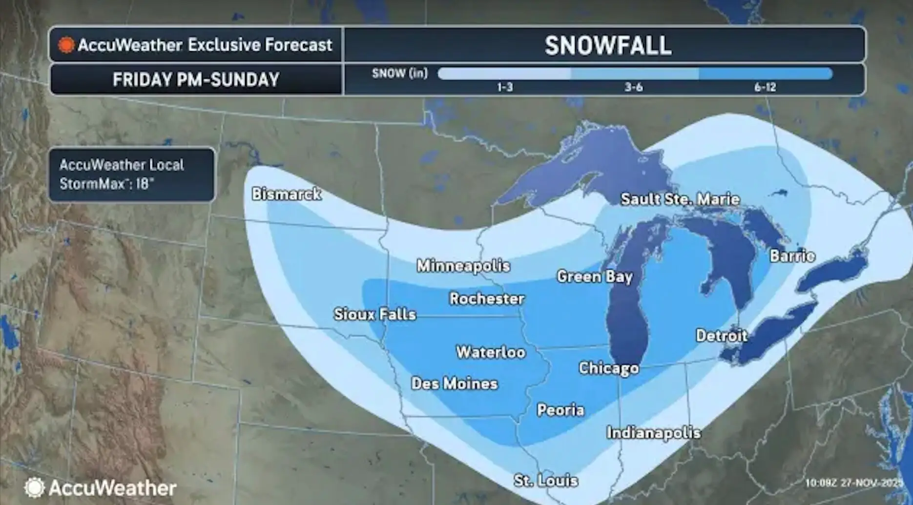
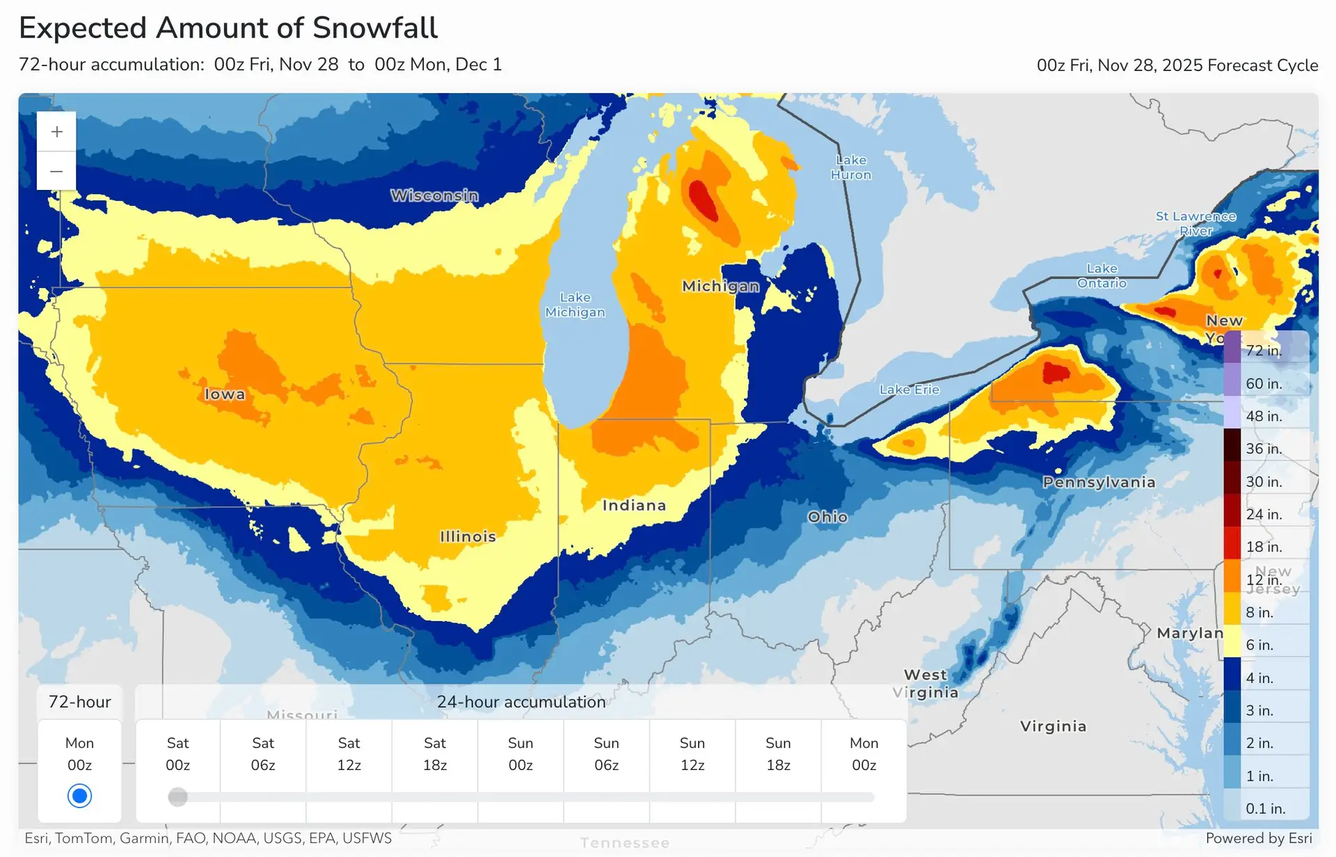
AccuWeather predicted a wider range of snow totals in the heart of the Midwest with 6-12″ of snow from far eastern South Dakota through Michigan, and less than 6″ for surrounding areas. The U.S. National Weather Service (NWS) predicted higher totals in some areas, with 12-18″ forecasted in central Iowa and the Indiana/Michigan border, as well as other lake-effect snow-prone areas. A few areas of 18-24″ snowfall areas are highlighted in prominent lake-effect snow areas.
So, were the forecasts accurate? Let’s dig into the data.
Generally, all three forecasts were spot on with the majority of the heavier snow totals falling in the heart of the Midwest and in lake-effect areas, with sharp cutoffs in snow totals surrounding those areas. Now, let’s look at some specific regions.
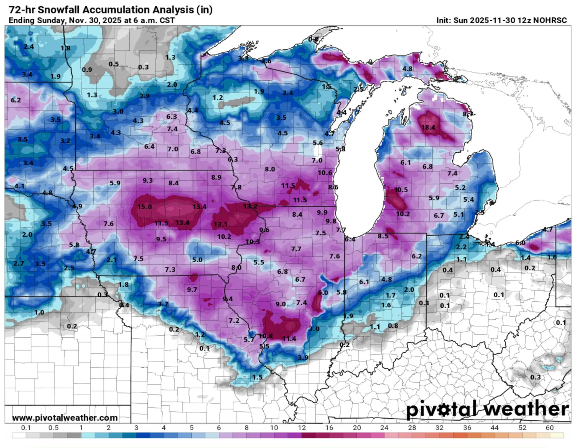
In central and eastern Iowa, The Weather Channel predicted 8-12”, AccuWeather predicted 6-12”, and the NWS predicted 8-12” widespread and 12-18” in numerous counties. According to snowfall analysis gathered from various sources and put together by NOHRSC, multiple locations in central and eastern Iowa received 13-15” of snow, with surrounding areas well within the 8-12” swath of snow. Kudos to the NWS for being the only entity out of these three that predicted areas above a foot when more than a foot of snow fell in this area.
The St. Louis, Missouri area is one area that stands out. Although borderline to multiple snow ranges on the map, The Weather Channel had 3-5” of snow forecasted for St. Louis, with higher totals just over the Illinois border. AccuWeather predicted 3-6” for the same area. The NWS also had multiple snow ranges bordering St. Louis in their snowfall map, with generally 2-4” predicted, also with higher totals just over the Illinois border. According to reports gathered by NOHRSC, numerous locations received 6-8” of snow, with nearly a foot of snow seen just across the Illinois border. All three providers in this quick analysis under-predicted snow for this area.
Across Indiana, all three providers forecasted a sharp cutoff in snow totals from northwestern Indiana to southeastern Indiana. The Weather Channel predicted 8-12”, AccuWeather predicted 6-12”, and the NWS predicted 12-18” in NW Indiana. There were numerous reports of 8-10” of snow in that area, and a few reports nearing a foot of snow on the Indiana/Michigan border. The NWS seemed to over-predict snow in northwestern Indiana, while AccuWeather was largely spot on with their forecast, and The Weather Channel hit on the upper bound of their prediction, with some totals higher than forecast.
For northern Michigan, the lake effect machine was cranking earlier on in the forecast period. The Weather Channel generally predicted 5-8” for the area. AccuWeather forecasted 6-12”, although their forecast map begins Friday night and may not have included the lake effect snow received throughout the day Friday. The NWS had much higher predictions for the lake effect snow in northern Michigan earlier on in the forecast period, with a forecast of 12-18+”. Ultimately, 17+” of snow fell in that area.
Of course, there are many factors that can contribute to snowfall forecasts verifying or not. The exact path that the low pressure system takes can greatly affect where the sharp cutoff in totals may be. Sometimes a 20 mile difference can be the difference between no snow and 8” of snow. Surface temperatures and atmospheric temperatures also play a role in the type of precipitation that falls. When temperatures are close to the freezing point like they were during this system, slight variations in temperature can cause the precipitation to change either to or from snow/rain, impacting snow totals. Even advanced computer models can struggle to predict these fine details of winter storm systems.
The ForecastWatch suite of solutions offers a variety of ways to better understand the value and quality of weather forecasts to meet the needs of meteorologists, corporate clients, and media partners. If you could benefit from our accuracy data and analysis, contact us today at info@forecastwatch.com.
